Have you ever seen small wooden stakes on a piece of property and wondered what they were? Those stakes are property markers and are placed at the four corners of a piece of property. These corners are marked after a boundary survey is performed for a property.
When buying, subdividing, improving, or building on a piece of property it is highly recommended that you obtain a boundary survey. This formal document clearly defines the boundaries of a property, based on research and deeds with the city that define the true corners of the parcel of land.
As a builder we are required to obtain a boundary survey for any new construction home we build. We use the information obtained in the pre-construction phase to ensure the improvements on the lot fall within the boundaries and guidelines outlined in the final survey.
What information does a Boundary Survey Include?
The formally defined boundaries are based on the property’s legal description with the city. As a builder the boundary surveys we commission, include the property corners and any setback requirements, easements around the property, any limitations imposed on the property, the elevation and whether the property resides in a flood zone.
All this important information is used to determine the placement and plausibility of building a home on a specific piece of land taking all the above information into consideration. Clearly defined property attributes are used to ensure the home our clients wish to build meets all the necessary constraints and guidelines for the property.
The boundary survey indicates the property’s virgin ground, which helps to determine the house pad height requirement in order to comply with flood elevation requirements set by FEMA. Any indication of wild life will also be marked on the survey for consideration.
A client’s lender also uses the information on a boundary survey to identify whether there are any encroachments present on the property, and legal description is verified.
Who provides a boundary survey?
A boundary survey must be executed by a licensed surveyor and mapper. Defining boundaries is an important legal task. This survey is a legal document, and the surveyor must comply with state rules and regulations when detailing the property lines.
Research about the property and the deed of the land with both public and private agencies is conducted. A field worker will locate, define, and verify each corner of the property with a marker (often a stake with a small flag) to clearly establish the property corners. After these processes are finalized, the final plan or drawing is prepared. The boundary survey contains the results of all the findings and recommendations in a visual representation that is provided to the contracted person(s).
Conclusion
As you can see, a boundary survey is an instrumental tool for builders and transactions involving the buying or selling of land. The information a boundary survey provides is important for builders in defining the pre-construction process to ensure the land is clearly defined and improvements on the land fall within the land’s legal description and guidelines. The setup of a boundary survey may differ depending on your location, so check with your local building department or your builders permitting department should you have questions about your boundary survey.
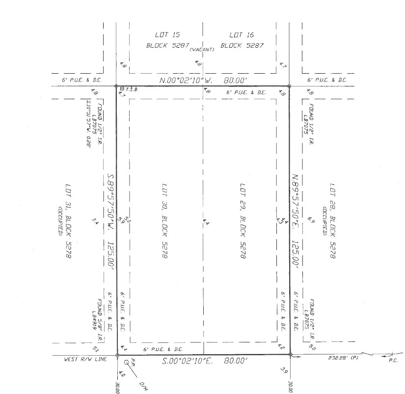
Example of a Cape Coral, FL Boundary Survey – Image 1: